
Storm Damage in Western Kentucky: What to Do After the August 19-20 Storms
By Fit Roofing
Severe storms moved through western Kentucky the night of August 19 to 20, 2026, and Graves County took the worst of it, with an 80 to 105 mph macroburst tearing east-southeast across the northern half of the county. Calloway, Marshall, McCracken and Trigg also saw damage. If your roof took a hit, here’s what actually matters right now.
Quick answer: Graves County was hit hardest, and this was a wind and rain event, not a hail event, with winds to 105 mph and one confirmed EF-1 tornado. Stay off the roof, check for water inside, get a tarp on any exposed area, and get an in-person inspection before you decide anything else.
What actually happened the night of August 19-20?
A line of severe thunderstorms crossed western Kentucky overnight, and the National Weather Service office in Paducah has since published an official summary of the damage. According to that summary, a macroburst, a burst of straight-line wind spreading out from a collapsing thunderstorm, tore across Carlisle and Graves counties with winds estimated at 80 to 105 mph. The highest wind gust actually measured by an instrument was 82 mph at Murray Airport in Calloway County.
The same storm system produced one confirmed tornado, rated EF-1, that touched down in Carlisle County about 3 miles east-southeast of Cunningham. It carried peak winds of 100 mph, reached a maximum width of 75 yards, and traveled 1.5 miles before lifting near Lowes in Graves County. Rainfall in the heaviest swath ran 3 to 7 inches over 24 hours, on top of the wind.
NWS Paducah lists significant damage across eight Kentucky counties: Carlisle, Graves, McCracken, Calloway, Marshall, Trigg, Christian, and Todd. Fit Roofing’s own service area covers Calloway, Marshall, McCracken, Graves, Lyon, and Trigg, and five of those six counties are on that damage list. Carlisle, Christian, and Todd counties, also hit hard, fall outside where we work.
One correction worth being direct about: reports have circulated online about 2 inch hail from this storm system. That hail fell near Van Buren, Missouri, a different state, a different storm cell. It did not fall in western Kentucky. What came through here was wind and rain, not hail, and that distinction matters for what your roof is actually dealing with, which we get into below.
Source: NWS Paducah, Summary of Severe Thunderstorms on August 19-20, 2026
Why did Graves County get hit the hardest?
Because the macroburst core ran straight through it. The NWS traces the macroburst starting just northwest of Cunningham in Carlisle County and then continuing east-southeast across northern Graves County, carving a damage path roughly 18.5 miles long and nearly 8 miles wide. That is a wide, sustained corridor of 80 to 105 mph wind rather than a brief gust, which is why Graves came out of this worse than anywhere else in the region.
Reports came in from Mayfield, Fancy Farm, Lowes, Folsomdale and Hickory. The NWS summary describes widespread tree damage, numerous outbuildings heavily damaged or destroyed, a gas station awning knocked over, and an outbuilding blown onto nearby trucks near Folsomdale.
The line that matters most if you live there: NWS specifically notes several homes that suffered some degree of shingle or roof damage. If your home is anywhere in that northern Graves corridor, assume your roof is worth checking even if it looks untouched from the driveway, because at those wind speeds the most common outcome is not a hole in the roof, it is shingles broken at the seal that settle back down looking fine. More on what that looks like below.
What should you do before anything else?
Check on people first, then the house, then the roof, in that order, and don’t get on the roof yourself. A few things to run through right away:
- Stay away from any downed power line, even one that looks dead. Treat every line as live and call your utility to report it.
- Don’t climb onto a storm-damaged roof. Decking can be weakened or broken in ways you can’t see from a ladder, and loose shingles or exposed nails are easy to slip on. Walk the yard and look up from the ground instead.
- Check your attic and ceilings for water. A wet spot, a drip, or a new stain means water is getting in somewhere, and that’s worth acting on today, not next week.
- If water is actively coming in, contain it from inside. A bucket under a drip, a tarp draped inside the attic over insulation, moving anything valuable out from under a wet ceiling. Do this from inside the house, not by getting on the roof.
What does 80 to 105 mph wind actually do to a roof?
Wind damage and hail damage are different problems, and this storm was overwhelmingly a wind event. Straight-line wind that strong gets up under the edge of a shingle and pries at it. What that typically looks like:
- Creased or lifted shingles. Wind can bend a shingle back far enough to crack its seal, and it can settle back down looking almost normal afterward. It looks fine and isn’t. Once that seal is broken, the shingle doesn’t reseal on its own, and it’s more likely to lift again in the next wind or let water underneath.
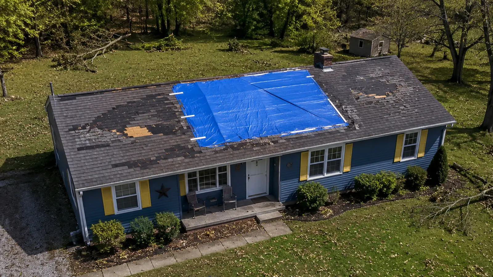
- Torn-off tabs and bare patches. At the higher end of what this storm produced, wind can rip whole shingles or sections of shingles off outright, leaving bare decking, the wood layer underneath, exposed to the weather.
- Exposed nails. Where shingles are gone, the nails holding the course below are often exposed too, and every one of those is a potential leak point.
- Peeled ridge cap and flashing. The cap along the roof’s peak and the metal flashing around chimneys and vents are both more exposed to wind uplift, and both are easy to miss from the ground if they’re only lifted, not gone.
- Debris impact. Limbs and branches coming down in wind this strong can crack, puncture, or gouge shingles wherever they land.
The important difference from hail: hail damage is often invisible from the ground, a bruise under the surface of the shingle mat that only shows up on close inspection. Wind damage is frequently the opposite. Missing shingles, bare decking, and a tarp-worthy hole are usually visible just by looking up. But not always all of it. A shingle can look flat and back in place and still be broken at the seal underneath, which is exactly why a ground-level look isn’t the same thing as a real inspection.
What should you do in the next few days?
Once everyone’s safe and the immediate water is under control, work through these in order.
- Document from the ground before anything is moved or repaired. Photos and video of the roof, the yard, any debris, and any interior water damage, with today’s date. Do this before a tarp goes up or anything gets cleaned up, since it’s the clearest record of what the storm did.
- Get emergency tarping in place. A tarp over exposed decking or missing shingle sections stops the immediate bleeding while everything else gets sorted out. It’s a temporary measure, not a repair, but it’s the thing that keeps a roof problem from becoming a ceiling, insulation, and drywall problem too.
- Contact your insurance company or agent. Let them know what happened and ask what they need from you. If you want to understand what a roof claim actually pays before you make that call, we wrote a plain-English walkthrough of replacement cost versus actual cash value coverage, including the worked math on an older roof. Your policy, deductible, and coverage are between you and your insurer. We can’t tell you what will or won’t be covered, and we won’t promise you an outcome on a claim, that’s not ours to promise.
- Get an in-person inspection. Ground-level photos and a walk around the yard tell you there’s a problem. They don’t reliably tell you how bad it is or where every point of damage sits. Someone trained to check the roof itself, safely, is how you find out what you’re actually dealing with.
Why does temporary tarping matter so much?
Because water doesn’t wait for your schedule. Western Kentucky in late August still sees regular afternoon rain, and exposed decking left open to the weather can let water into the attic with the very next shower, sometimes within hours of the storm that caused the damage in the first place. Once water gets into insulation, ceiling drywall, and framing, you’re no longer dealing with one problem, you’re dealing with a roof problem and a water damage problem, and the second one is often the more expensive of the two. A properly strapped emergency tarp buys you the time to get a real inspection and a real repair plan without the damage getting worse while you wait.
Does storm damage always mean a full roof replacement?
Plainly: some roofs came through this fine, and an inspection is how you find out which kind you have. A few creased shingles or a lifted section of ridge cap on an otherwise sound roof is often a straightforward repair. Widespread bare decking, multiple torn sections, or shingles broken at the seal across a large area is a different conversation. The only honest way to tell the difference is to have someone look, in person, at the actual roof, not to guess from what you can see standing in the driveway.
What should you watch for with out-of-town roofing crews right now?
After a storm like this, trucks from out of state show up fast, and most of that work is legitimate. A little bit of diligence protects you either way:
- Ask for a local, verifiable address, not just a phone number or a truck with magnetic door signs.
- Verify their license and insurance before signing anything, and don’t just take their word for it.
- Don’t pay a large amount upfront in cash, and don’t sign a contract on the spot under pressure to decide today.
Fit Roofing is based in Murray, Kentucky. We were serving these six counties before this storm and we’ll be here after it, for the inspection, the repair, and anything that comes up down the road. That’s true of plenty of good local crews, not just us, so use the same checks with anyone you’re considering.
How do you reach Fit Roofing?
Call 270-FIT-ROOF (270-348-7663) or reach out through our contact page. If your property needs more than the roof itself, our storm restoration team handles that too. We’ll walk the roof, tell you plainly what we see, and help you sort out what needs to happen next.
Questions
Frequently Asked Questions
Which county was hit hardest by the August 19-20 storms?
Graves County. The National Weather Service in Paducah traces the macroburst core east-southeast across northern Graves County, carving a damage path about 18.5 miles long and nearly 8 miles wide with winds of 80 to 105 mph. Reports came from Mayfield, Fancy Farm, Lowes, Folsomdale and Hickory, and NWS specifically notes several homes with shingle or roof damage. Calloway, Marshall, McCracken and Trigg counties also saw damage.
What caused the roof damage from the August 19-20 storms?
Straight-line wind, not hail. The National Weather Service in Paducah confirmed a macroburst across Carlisle and Graves counties with winds of 80 to 105 mph, plus an EF-1 tornado in Carlisle County with peak winds of 100 mph. The highest measured gust in our service area was 82 mph at Murray Airport in Calloway County. The widely shared report of 2 inch hail was from Van Buren, Missouri, not Kentucky, and it is not part of what hit this area.
Is it safe to go up and check my own roof after this storm?
No, not right after wind damage like this. Broken decking, loose shingles, and exposed nails can give way without warning, and you can't always see structural damage from a ladder. Do a walk around the outside from the ground and check your attic and ceilings for water, but leave the roof itself to someone with the right gear and training.
How fast do I need to get a tarp on my roof?
As soon as you can safely arrange it, ideally within a day or two. Kentucky in August brings frequent afternoon showers, and an area of missing shingles or exposed decking left uncovered can let water into the attic and ceilings with the next rain, turning one problem into two. A tarp is a temporary fix meant to buy time until a proper repair, not a substitute for one.
Should I sign a repair contract with the first roofer who knocks on my door?
Take your time, even when the crew seems friendly and available today. Ask for a local address, verify their license and insurance, and don't hand over a large payment upfront or sign anything on the spot. A company with a real, permanent presence in this area will still be here next month if you need them back.
Storm Or Planned, We've Got You
Roof emergency, or just planning ahead? Either way, one call fixes it.
Storm damage gets answered day or night. A new roof gets a straight, no-pressure estimate. Same crew, same standard, every time.